9.28.2008

Rock Formation of Cappadocia

Cappadocia is the common name of the plains and mountainous region of eastern central Anatolia around the upper and middle reaches of the river Kizilirmak. It's name is said to be derived from Hittite language, Katpatuka, which means land of the beautiful horses.

beautiful rock formation of Cappadocia
A beautiful rock formation of Cappadocia. Source: http://flickr.com/photos/terdata


This region's amazing landscape is largely underlain by sedimentary rocks formed in lakes and streams, and ignimbrite deposits erupted from ancient volcanoes approximately 9 to 3 million years ago (late Miocene to Pliocene epochs). The volcanic deposits are soft rocks that, for hundreds of years, the people of the villages at the heart of the Cappadocia Region carved out to form houses, churches, monasteries and underground cities. Forces of erosion have shaped the incredible and unique Cappadocian tuff-coned landscape. This nature and man made structures now make a popular tourist destination.

view of Cappadocia Rock Formation
A view of Cappadocia Rock Formation. Source: wikipedia.org
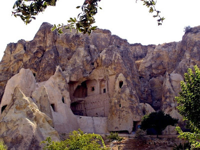
A church carved from the rock in Cappadocia
A church carved from the rock in Cappadocia. Source: flickr.com/photos/morgui
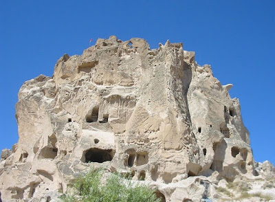
Uçhisar Hill and Castle, the highest point in Cappadocia<br />
Uçhisar Hill and Castle, the highest point in Cappadocia. Source: wikipedia.org


Cappadocia is also famous for it's fairy chimney - a conical rock formation which consist of a cap of hard rock resting on a cone-shaped pinnacle of softer rock
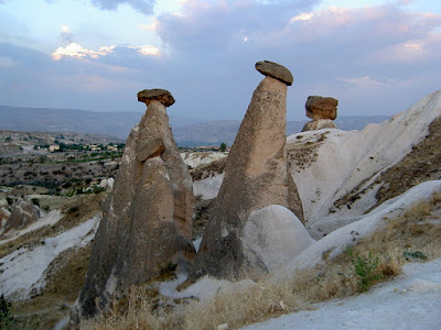
<br />Fairy chimneys in Cappadocia
Fairy chimneys in Cappadocia. Source: wikipedia.org

Fairy chimneys in Cappadocia. Source: flickr.com/photos/morgui

9.26.2008

World's Natural Wonders Video - Part 1

I decided to share the world's natural wonders I posted last month via YouTube. I plan to make it monthly. So it check here monthly for new videos.

9.23.2008

Mekong River, Asia's 7th Longest River

The Mekong river is the 11th longest river in the world. It run in six countries - China's Yunnan province, Burma, Thailand, Laos, Cambodia and Vietnam. With it's length of 4,350 kilometers, it is the 7th longest river in Asia. It discharges an estimated of 475 km3/114 cu mi of freshwater to the sea annually and it drains an area of 795,000 km2.

Map of Mekong River
Map of Mekong River. Source: hereticdhammasangha.wordpress.com


Because of it's massive size, no wonder Mekong is home to the world's giant freshwater fishes. This giants are now becoming small in number due to human activities.

giant catfish of mekong
Giant catfish of Mekong River. Source: nationalgeographic.com

Giant of barb Mekong River
Giant of barb Mekong River. Source: nationalgeographic.com


The name "MEKONG" originate from the Thai language, Mae Nam Khong, which means "Mother-River Khong".

Evening in the Mekong River. Source: flickr.com/photos/hschmid


Mekong river serves as a major transportation and economic route to all villages around it.

river market in mekong river
Market in the Mekong River. Source: flickr.com/photos/kateyaeger

Two boats in the Mekong River
Two boats in the Mekong River. Source: flickr.com/photos/hschmid

9.22.2008

Amazon River, World's Largest River

The Amazon river is the largest and the second longest river in the world. It is so huge that it covers six countries, Peru, Colombia, Brazil, Bolivia, Venezuela, and Ecuador. It has the largest drainage basin in the world and accounts for approximately one fifth of the world's total river flow.

During the dry season, the river covers and area of 110,000 square kilometers, while in the wet season the area rises to 350,000 square kilometers. At its widest point the Amazon River can be 11 kilometers wide during the dry season and 45 kilometers wide during the wet season.

Satellite image of the mouth of the Amazon river
Satellite image of the mouth of the Amazon river. Source: wikipedia.org

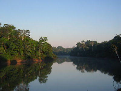
morning in the amazon river
A beautiful morning in the Amazon. Source: flickr.com/photos/markgee6

The Amazon river originates from the Apacheta cliff in Arequipa at the Nevado Mismi, with a sole sign of a wooden cross.. Source: wikipedia.org


Amazon river is also home to one of the world's largest fishwater fish, the Pirarucu. Sadly, this fish is dwindling in numbers due to over fishing. Here's a video of a study funded by the National Geographic.

9.17.2008

Guilin Mountains, The Spectacular Misty Mountains

The Chinese city of Guilin is home of the Guilin Mountains - the spectacular misty mountains in all shapes and sizes that rises out of the water to form dramatic settings. These mist-shrouded limestone mountains was carved by the Li River. Today, the city of Guilin attracts innumerable tourists because of its unique landscape. Until the end of the 1970s, it was a quiet, sleepy area. Since then, Guilin and the settlements along the Li River have undergone an incredible development through tourism.

Guilin Mountains, The Spectacular Misty Mountains
Source: flickr.com/photos/qilin

Guilin Mountains, The Spectacular Misty Mountains
Source: flickr.com/photos/sibertekt

Guilin Mountains, The Spectacular Misty Mountains
Source: flickr.com/photos/sibertekt

9.16.2008

Jeita Grotto

The Jeita Grotto of Lebanon is a compound of crystallized caves located 20 km north of Beirut, Lebanon in the Valley of Nahr al-Kalb or Dog River. This grotto complex is composed of two caves - the upper galleries and lower cave. The upper galleries was discovered in 1958 by Lebanese speleologists, while the lower cave where an underground 6230-meters-long river runs was discovered in 1863 by Reverend William Thomson. The grotto complex was nominated in the New Seven Wonders of the World.

The cave and galleries is home to one of the biggest stalactites in the world hanging 8,20 meters from the ceiling. Carved from the limestone by water are cathedral-like vaults with various sizes, colors and shapes. The cave is more than 9000 meters in length and 108 meters in height from the ceiling to the water level.

jeita grotto
Source: jeitagrotto.com

jeita grotto
Source: jeitagrotto.com

jeita grotto
Source: jeitagrotto.com

9.15.2008

Cedars of Lebanon

The Cedars of Lebanon are evergreen coniferous trees growing up to 40 meters tall, with trunk of up to 2.5 meters in diameter. In early days, the Mount Lebanon chain used to be almost completely covered with cedars. These trees has always been a national emblem of Lebanon, in fact a cedar tree is in the middle of the Lebanese flag.

Since ancient times, these trees has always been significant to the people in the middle east. The Egyptian used its resin to mummify their dead, others burned cedars during offerings and ceremonies and also for medicinal purposes. It was also used for shipbuilding during those times.

Today, Cedars of Lebanon are most sought after because of it's good quality of wood - hard, fragrant, resistance to insects and humidity and temperature. This resulted to decreasing numbers of cedars trees in the region.

Source: wikipedia.org

Source: habeeb.com

Source: flickr.com/photos/anahon

9.13.2008

Iguazu Falls, Argentina's Top Tourist Attraction

Iguazu Falls is one of Argentina's top tourist attraction and the most visited place in the Argentinian province of Misiones. In guarani language, the term "Iguazú" means "great waters".

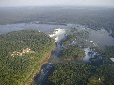
The falls was discovered in 1541 by Alvar Núñez Cabeza de Vaca and established as Natural World Heritage Site by UNESCO in 1984. It marks the border between Argentina and Brazil. It has 275 individual cascades which spread in a 2.5 miles horsehoe shape cliff which are the result of a volcanic eruption. During the rainy season the rate of flow of water going over the falls may reach 450,000 cubic feet (12,750 cubic m) per second.

Iguazu Falls, Argentina's Top Tourist Attraction
Iguazu Falls, Argentina's Top Tourist Attraction (Source: wikipedia.org)


Iguazu Falls, Argentina's Top Tourist Attraction
Panoramic view of Iguazu Falls (Source: wikipedia.org)


Iguazu Falls
View from the foot of the falls (Source: wikipedia.org)

9.12.2008

Sundarbans, World's Largest Mangrove Forest

Located between Bangladesh and India, Sundarbans is the world's largest mangrove forest. It lies in the mouth of the Ganges river and is composed of mangrove forests, swamps and forest island all interwoven in a network of small rivers and streams. It covers an area of approximately 10,000 square kilometers.

Sundarbans is home to the Royal Bengal Tiger and many different animals including species of birds, spotted deer, crocodiles and snakes. It is considered a UNESCO World Heritage site and was designated a Ramsar site on May 21, 1992. It was also nominated as one of the New 7 Wonders of the World, though didn't make to the final 14.

Source: wikipedia.org

Source: wikipedia.org

9.11.2008

Cox's Bazar Beach, World's Longest Natural Beach

The Cox's Bazar Beach is considered the longest natural beach in the world. Situated in the town of Cox's Bazar in Bangladesh, this unbroken 125 km sandy beach is one f Bangladesh's major tourist attraction.

It is also known as "Panowa", meaning "yellow flower" It was first named as "Palongkee" before it was changed to Cox's Bazar, in honor of an army officer, Captain Cox, who serve in British India and died on 1798.

A typical busy day at Cox's Bazar. Source: flickr.com/photos/nafis_kamal

Fisherman's boats along the beach. Source: wikipidea.org

9.02.2008

Angel Falls, World's Highest Waterfall

The Angel Falls is the world's highest waterfall at 979 meters and also the world's highest single drop at 807 meters. It is located in the Canaima National Park, in the Gran Sabana region of Bolivar State, Venezuela.

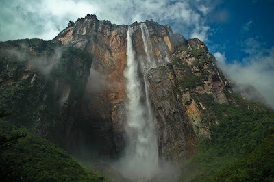
View from the foot of the angel falls
View from the foot of the waterfalls (Source: ent108)


Angel falls is so high that the water falling from it turns into mist before hitting the ground because of strong winds. It was discovered by American aviator James "Jimmie" Crawford Angel who flew over the falls on November 16 1933 while searching for a valuable ore bed.

Angel Falls
(Source: davidkjelkerud)

9.01.2008

The Matterhorn, the Pyramid-shaped Mountain

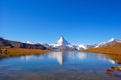
The Matterhorn is not the highest mountain in the Alps, but it is the most recognizable because of it's shape. It has four very marked ridges and faces that makes it look like a pyramid. The four faces are steep, and only small patches of snow and ice cling to them as regular avalanche clears it and deposits the snow on it's foot.

It towers it's surrounding villages at 4,478 meters and is located between the border of Italy and Switzerland.

The Matterhorn, the Pyramid-shaped Mountain
Source: http://wikipedia.org

matterhorn with reflection in the lake
Source: http://www.flickr.com/photos/ryanvaldez

The Matterhorn, the Pyramid-shaped Mountain
Source: http://wikipedia.org